
- Day 13, July 27: 32.1 miles, total miles: 380.3 – trails, powerline right of ways, and logging roads
- Parks, Trails & Places of Significance: Snoqualmie Valley Trail, Rattlesnake Ledge, Rattlesnake Mountain, Raging River State Forest, the Raging River, Tiger Mountain State Forest, PCC in Issaquah
Coffee with Alicia this morning. Then it was time to get our running packs in order and get out on the trail.
We lost a little time trying to follow an Open Cycle route up from Alicia and Andy’s house into a network of trails that lead to the Rattlesnake Lake trailhead. But after encountering several no trespassing signs we decided it wasn’t worth it and made our way back to the Snoqualmie Valley Trail and up to Rattlesnake Lake via the miles we’d biked 12 days ago.
If we thought Si was popular yesterday afternoon… well then. Rattlesnake Lake and the ledges are an order of magnitude up in density. Maybe two. It’s a total show. Perfumed people. People blaring music from portable sound systems. Tons of families. Tons of dogs. Kids cutting switchbacks. 9:00 am on a summer Friday is BUSY at Rattlesnake Lake. There’s practically a queue on stretches of the trail. With so many people going by all time, I wondered how there could be so much toilet paper on the side of the trail.
I hadn’t been up this trail in a good 10-12 years, so it was insightful for me to see how impacted it is and get a sense of what typical users experience. Rattlesnake is a popular hike in our region and if people that go there see lots of toilet paper flowers discarded along the trail, micro trash all over, hear the loud music of other hikers, smell strong perfume on people – they may normalize all sorts of actions and behaviors that I was taught were unacceptable and poor etiquette to do while hiking. I’m not trying to confine hikers to “one right way” but a lot of these behaviors impact the experience of other hikers and disturb the natural beauty and creatures we are all out to enjoy. Hiking among the Rattlesnake ledge crowds renewed my intentions to take a Leave No Trace class so I can better speak to others about why it’s important to do things in a way that protects the trail.
We hoofed up and by people as quickly as possible. Took an obligatory stop at the ledges to be reminded of what the fuss is about (it is a nice view that doesn’t require much effort). And got out of dodge heading up the Rattlesnake Ridge trail over the mountain and down the other side. Away from the ledge the trail goes through young third growth forests, nice second growth, and has views of the Snoqualmie Valley, Si, Rainier, and more distant peaks. It’s a lot less crowded and far more quiet. We ran some stretches and hiked others.
By early afternoon we transitioned from the shady forested Rattlesnake trail to the series of mountain bike paths and power line right of way corridors in the Raging River State Forest. Here we saw a bear! Our one sighting of charismatic mega-fauna for the whole trip. The black bear was in the shade eating berries and reluctantly got up and moved on as we were walking by below it. Sorry to disturb you Bear! You who are so much smarter than us, sitting in the shade eating berries while we walk in the sun.
This stretch of miles was hot in full sun, steep going, and thick with blackberry and other prickly plants. To think, one time this corridor was part of a Mountains to Sound Greenway trek – tough hikers! But this is the connector land. And someday, according to DNR’s plans, there will be some sort of trail system that lets bikers, hikers, and equestrians go from Tiger Mountain to Rattlesnake. Until then, on a July afternoon, it’s a hot walk in blackberry cane and thistle country. We cowered in patches of shade, shook out grasses and seeds from our shoes, got drinks of electrolyte mixes and braced ourselves for the next “pitch” of trail.
The storied, but faint route funneled us under Highway 18 to a ford of the Raging River. Raging it could be in the fall or during a rain on snow event, but not today. It was a rock hop with the highway for shade. Graffiti on the columns. Pop bottles, wrappers, and other debris – all reminders that we are getting closer to densely living people. In fact, the suburban-urban corridor that surrounds Seattle was just on the other side of Tiger Mountain.
We saw a few hardy mountain bikers in the distance pushing bikes up the hot open slopes of east Tiger under the power lines. So we pushed on in their direction – knowing that soon enough we’d be on the trail network of well-forested Tiger Mountain. 3:30 in the afternoon on an 80-something or 90-degree day just isn’t a nice time to hike through grasses and blackberries. But if you keep walking you eventually get to something you like. The crumby stuff doesn’t last that long, and your hot, addled brain doesn’t really take in all the discomfort anyway. Either that, or it’s good training.
At last! We got onto the good mountain bike trails on the southeast side of Tiger Mountain with shade and creeks. The forest was beautiful, the trail surfaces in great shape, and the temps out the sun were comparatively cool. We got our brains back to more alert mode and started moving better. Jogging the flats and down hill sections. By no means going fast, but doing far better than out under the sun and power line right of way.
We ran familiar trails and logging roads. We were tempted a few times to take social trails with cairns out to neighborhoods to see if we could get down to the main road into town via a more direct route – but the paths we took led us to no trespassing signs. :-p Why do you put up a cairn if the trail doesn’t go through? After 12 days of publicly accessible paths and trails – it was frustrating to encounter these barriers off of waypoints that usually mean “this way goes”. I took down those cairns and made them into trail barriers to symbolize what they really meant. I also realized how insignificant these blockages were compared to what’s been happening in other parts of the West in Idaho and Montana where vast tracks of public lands have been effectively blocked off by private acquisitions. Thinking about those areas has me so grateful that public land managers and conservation groups here in Washington have the resources to keep public lands accessible and are working to make them more so.
At a certain point in the evening – maybe around 6 pm or so. The only motivation to put one foot in front of the other was PCC in Issaquah. Knowing they had the emerald city salad, kombucha, fresh fruit, and burritos awaiting purchase in the magnificent deli. Maybe even a slice of pizza. We got to our legit, mapped exit of Tiger Mountain and hoofed down a steep dusty road to the Issaquah Hobart Road. We probably could have hitched. But this is the suburbs/exurbs with cell service in an area with Lyft/Uber so we turned on an app and got a ride into Issaquah. Gosh thru-hiking has changed since 2011. We had our kind driver take us to the grocery store.
We had a reservation for the Holiday Inn, just across the parking lot from PCC. Backpacks and shopping bag full of food, we limped stiff legged into the motel (how can a motel be more than $250 a night!? Turns out, it’s summertime in the Puget Sound region). It felt like a long walk to our room. And the key didn’t work at first. But finally we got in. Feasted. And showered. The bed felt soooo good. We zonked out, knowing we had one last 30+mile day and we’d be home.

Fresh shoes for the trail running leg of the trip.

So much for the trail we saw on Open Cycle maps to get up to Rattlesnake Lake, we’ll go back down to the Snoqualmie Valley Trail to make sure our route is all publicly accessible.

Mt. Si and Teneriffe from Rattlesnake Mountain.
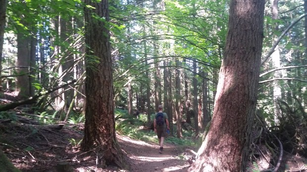
Shady trails on Rattlesnake Ridge.

The powerline ROW in the Raging River State Forest. It was right around here that we saw the black bear chomping on berries – in the shade. Smart bear.

Gabriel crossing the mighty Raging River.

Looking back at busy Hwy 18. Glad we crossed under the highway and didn’t have to dodge semis and speeding cars.
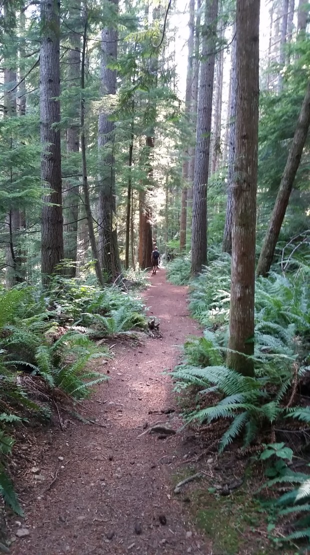
Lovely lovely trails in beautiful Tiger Mountain State Forest and NRCA. Thanks DNR and everyone who works to ensure this forest is a well-maintained recreation destination for hikers, runners, mountain bike riders, and equestrians AND is also well-managed to the Forest Stewardship Council standards to provide timber revenues for schools and sustain local economies.

Late late late afternoon on an uphill section of Tiger Mountain State Forest. Pretty clouds, nice silvicultural treatments in the stands that have been harvested around here. But gosh are we ready to get off our feet and eat good food.

Made it to Issaquah! And PCC where they have delicious kale salads and kombucha. Mukmuk was ready for the royal treatment. We were happy to get blackberry thorns out of our legs and consume a large number of calories that didn’t come from a gel or bar package.
